Neighbors Against Irresponsible Logging
NAIL Blog
| Title | Author | Date Posted |
|---|---|---|
| Letter from Assemblymember Ira Ruskin | Rebecca Moore | Oct 3 2007 - 8:20pm |
| Letter to CDF from Prof. Don Erman | Rebecca Moore | May 21 2007 - 6:49pm |
| Thank You Residents For Your Fundraising Support! | Terry Clark | Mar 26 2007 - 5:10pm |
| L.G. Town Council Studies Dangers of Logging in Mountains | Terry Clark | Mar 24 2007 - 8:49am |
| Directions to NAIL Benefit Auction/Concert | Rebecca Moore | Mar 17 2007 - 12:48pm |
| Silicon Valley Metro: "Log Jam" | Rebecca Moore | Feb 13 2007 - 3:26am |
| SJ Mercury News: Neighbors use high-tech tools to challenge logging plan | Terry Clark | Feb 1 2007 - 8:45am |
| SJ Mercury Editorial Opposes Logging Plan | Terry Clark | Feb 1 2007 - 8:39am |
| SJ MERCURY ARTICLE RE: LOGGING PLAN | Terry Clark | Jan 27 2007 - 11:30am |
| Current Information on Public Hearing/Second Time Change | Terry Clark | Jan 10 2007 - 7:20pm |
Public Meeting Notice
Community Wildfire Protection Plan
Please join us Wednesday, April 29 for an open public meeting to discuss the results of the Community Wildfire Protection Plan.
The meeting is an opportunity for LEXINGTON HILLS CITIZENS AND CONCERNED STAKEHOLDERS to provide their comments in what will become the certified Community Wildfire Protection Plan, a 2003 directive by the U.S. Congress.
LOCATION: Redwood Estates Pavilion
21450 Madrone Ave:
Los Gatos, CA 95033
TIME: Wednesday, April 29, 2009
7:00 PM to 9:00 PM
SPONSORS:
- Santa Clara FireSafe Council
- CAL FIRE
- San Jose Water Company
- Aldercroft Heights Co. Water District
- Chemeketa Mutual Water Company
- Midpeninsula Regional Open Space District
- Santa Clara County Fire Department
- Santa Clara Valley Water District
- Santa Clara County Parks
- Redwood Estates Services Association
- Lake Canyon Mutual Water Company
- Santa Clara County Board of Supervisors
For more information, please contact:
Kim Gardner lexhills.sccfiresafe@gmail.com
Rick Parfitt RickP@SCCFireSafe.org
Rod Moraga, Anchor Point Group, (303) 665-3473
SAN JOSE WATER COMPANY (SJWC) NTMP APPEAL- DENIED!!
On October 8, Wednesday, at approximately 4:00pm, the California Board of Forestry, DENIED SJWC's Appeal.
We would like to thank the following people and organizations for helping us achieve this victory. We would not have made it without your support. (In no particular order)
Betsy Herbert
Ken and Gabrielle Adelman
Dennis Jackson
Toni McVey
Adelia Barber
CAL FIRE (for conducting an independent acreage assessment and standing behind their work)
Assembly Member Ira Ruskin
Assembly Member Jim Beall
Vice President Al Gore
Sierra Club, Loma Prieta Chapter
Paul Mason
Bill Young
Steven Ferla
Kevin Collins
Dennis Davie
Addie Jacobson
Bob Burns
Richard Montague
Philip Omi
Catherine and Bob Mende
Robert Moncrieff
Dick and Judy Klemann
Motor Punx
Shrink Circus
Lisa Sgarlato
Darrell Wolf
Patricia Webster
Cindy and Dana LoPiccolo-Giles
Catherine Russell
Cathy Daryle
Freddy Howell
Maryanne Moore
Karen Maki
Ed Dennis
Scott Stephens
Paul Rogers
Roger Sideman
Rachael Gibson
Santa Clara County Supervisor Don Gage (for listening to his constituents)
Nancy Long
The late Warren Davis
Mike Accorsi
Don Peters
Emma Kelly
Yelena Colodji
Garry Shapiro
Bill and Joan Moore
Vrinda Normand
Paul Couchi
Kathryn Ingram
Glynn Stout
Nathan Zaslow
Loretta Swanson
MaryAnne Murphy
Leslie Meehan
A very special thanks to:
Jodi Frediani (for her guidance, expertise and wisdom)
Although the NTMP has been denied, The NAIL Steering Committee wants you to know that, regardless of what comes next, we remain committed to the following:
- The issues of logging in this watershed still stand- it's a bad idea for Fire Protection, Water Quality and Land Stability.
- Should the water company ever submit a Timber Harvest Proposal in the future, the community will fight back.
NAIL encourages all efforts to create a public
trust with this land
so that it can be enjoyed in its natural state for
generations to come.
If you wish to make a donation to NAIL in order to support our continuing efforts to protect the Los Gatos Creek Watershed and support its acquisition for public open space, please click here: or send checks to:
MRG/NAIL
P.O. Box 1975
Los Gatos, CA 95031
We appreciate your support!
Your neighbors,
Terry Clark, Kevin Flynn, Rea Freedom, Rebecca Moore, Rick Parfitt, Linda Wallace, and Eric Horton
NAIL Steering Committee
To contact the NAIL steering committee, with questions, comments, ideas or offers to help with this effort, please email to:NAIL Steering Committee
NAIL is a non profit 501c3 organization relying on community dollars to keep logging out of our mountains.
Neighbors Against Irresponsible Logging (NAIL) formed in August, 2005 in order to protect the Los Gatos Creek Watershed and Thompson Road area from the San Jose Water Company's proposed logging operations with Big Creek Lumber.
There are many, many people who worked with NAIL and deserve your thank-you notes and letters. Please write to those listed below and express your thanks for all the work they did towards this plan denial:
California Dept. of Forestry and Fire Protection (CALFIRE)
135 Ridgeway Ave.
Santa Rosa, CA 95401
Attn: Ms.Leslie Markham
Chief Ruben Grijalva
CAL FIRE
PO Box 944246
Sacramento, CA
94244-2460
Richard Sampson
CAL FIRE
PO Box Drawer F-2
Felton, CA 95018-0136
Santa Clara County Board of Supervisors
70 West Hedding Street
San Jose, CA. 95110
Most important (our supervisor):
District 1 Supervisor Don Gage Tel: (408) 299-5010 Fax: (408) 295-6993 www.dongage.org
Copies to:
Supervisor Blanca Alvarado Tel: (408) 299-5020 Fax: (408) 295-8642 www.blancaalvarado.org
Supervisor Pete McHugh Tel: (408) 299-5030 Fax: (408) 298-6637 www.pmchugh.org
Supervisor Liz Kniss Tel: (408)-299-5050 Fax: (408) 280-0418 www.lizkniss.org
Assemblyman Ira Ruskin State Capitol P.O. Box 942849 Sacramento, CA 94249 (916) 319-2021 Fax (916) 319 - 2121 assemblymember.ruskin@assembly.ca.gov
Assemblymember Jim Beall : Capitol Office, State Capitol, P.O. Box 942849, Sacramento, CA 94249-0024
Tel: (916) 319-2024 Fax: (916) 319-2124
Beall's District Office: Capital Staff, 100 Paseo De San Antonio, Suite 300, San Jose, CA 95113
Tel: (408) 282-8920 Fax: (408) 282-8927
"Life on Google Earth", Common Ground Magazine (January 2009) by E.B. Boyd.
"Eyes in the Sky and on Your Desktop: With Google Earth, satellite images become an activist's ally", Sierra Club Magazine (Sept/Oct 2007) by Gregory Dicum.
"High-tech effort blocks San Jose Water Co.'s logging plan", San Jose Mercury News (September 29, 2007) by Paul Rogers.
"Cal Fire Denies Water Co. Logging Plan: Victory for Neighbors Against Irresponsible Logging", Los Gatos Observer (September 28, 2007) by Alastair Dallas.
"Log Jam", Silicon Valley Metro (February 7, 2007) by Vrinda Normand. (scroll down to article)
"Logging Alternative: Public Ownership", Los Gatos Observer (February 2, 2007) by Alastair Dallas.
"Neighbors use high-tech tools to challenge logging plan", San Jose Mercury News (February 1, 2007) by Paul Rogers.
"Battle Over Plan to Cut CA Redwoods" and "The Back Story: Redwood Battle", KGO TV (January 31, 2007) by Karina Rusk. (video)
"Logging plan excessive for future of watershed", San Jose Mercury News Editorial (January 31, 2007).
"Towering Battle: Residents Fight to save Redwoods, Douglas Firs", San Jose Mercury News (January 27, 2007) by Paul Rogers.
"What Else Are They Hiding?"and "NAILed It!", Silicon Valley Metro, Letters to the Editor (December 13, 2006) by Los Gatos residents C. Lee McKenzie and Ted Gehrke.
"Former vice president calls proposal 'flawed'", Los Gatos Weekly Times (December 6, 2006) by Jason Sweeney.
"A Leg up on Loggers", Silicon Valley Metro (December 6, 2006) by Vrinda Normand
"Technology builds bigger soapbox", San Jose Mercury News (December 3, 2006) by Scott Herhold
"Gore backs anti-logging effort", Los Gatos Daily News (December 2, 2006) by Kristen Munson
"Al Gore weighs in on local logging plan", Santa Cruz Sentinel (November 30, 2006) by Roger Sideman
"Mountain Residents Fight Water Co. Logging Plans", Local CBS evening news report (March 20, 2006) by Tony Russomanno. Video and transcript of program, including Google Earth flyover. (video)
"Los Gatos Mountain Logging Plan Sparks Fight", Local NBC11 evening news report (July 13, 2006) by Susan Siravo. (video)
"Mountain Residents Fight Water Co. Logging Plans", Local CBS evening news report (March 20, 2006) by Tony Russomanno. Video and transcript of program, including Google Earth flyover. (video)
"Tree
Reprieve", reporting withdrawal of the NTMP logging plan by
SJWC
San Jose Metro (Jan 4, 2006), by Vrinda Normand
"A buzz saw of protest: Eclectic neighborhood draws together
against logging plan"
San Francisco Chronicle (Dec 11, 2005), by Kathleen Sullivan
"Chopping Mad: Residents around Los Gatos Creek are up in arms
about San Jose Water's logging plan"
Silicon Valley Metro (Dec 7, 2005), by Vrinda Normand
"GREEN Eyes in the Sky: desktop satellite tools are changing
the way environmentalists work"
San Francisco Chronicle (Jan 11, 2006), by Gregory Dicum
June, 2006:
Logging News Update: In another attempt to seek permission to log 1002
watershed acres in the Santa Cruz Mountains, San Jose Water Company has
submitted a new NTMP to CDF.
The previously submitted NTMP was withdrawn in December of 2005.
The NAIL Steering Committee continues to actively oppose the logging plan and will track developments and keep you informed.
For additional information, updates, maps, FAQ’s and lists of people to contact to express your views, please visit the NAIL Forum.
San Jose Water Company NTMP Logging Plan DENIED!
This is a great victory for the residents of the Santa Cruz Mountains, as well as the forest, creeks and wildlife surrounding us.
On September 25th, 2007, the California Department of Forestry and Fire Protection (CAL FIRE) ruled that the San Jose Water Company NTMP logging plan application is "INELIGIBLE".
The reason for denial? As NAIL had previously determined and announced at the Public Hearing in January, SJWC owns too many acres of timberland to meet the legal definition of a "Non-industrial tree farmer".
The Details:
- The Forest Practice Act states that a non-industrial tree farmer must own less than 2,500 timberland acres.
- SJWC claimed in their NTMP application that they own only 2,002 timberland acres.
- Matt Dias (RPF of Big Creek Lumber) repeated this number many times to the media.
- NAIL determined that SJWC owns at least 2,754 timberland acres, and likely more
- CALFIRE agreed, concluding that SJWC owns approximately 2,825 timberland acres
What does this mean? Not only that the plan should have been denied, but also that it was never even eligible for consideration in the first place! We the taxpayers have funded a very expensive public review process, for two long years, for an application that did not even meet the basic submission requirements. And this acreage issue only came to light because of NAIL's efforts.
Useful Links:
"High-tech effort blocks San Jose Water Co.'s logging plan", San Jose Mercury News (September 29, 2007) by Paul Rogers.
"Cal Fire Denies Water Co. Logging Plan: Victory for Neighbors Against Irresponsible Logging", Los Gatos Observer (September 28, 2007) by Alastair Dallas.
"NOTICE OF INELIGIBILITY", (1.5MB pdf file) Sent to Mr. Matt Dias, RPF, Big Creek Lumber Company by CAL FIRE (dated Sept 25, 2007) "Letter from Assemblymember Ira Ruskin", to NAIL (September 27, 2007) by Assemblymember Ira Ruskin.
"San Jose Water Company Timberland Analysis": (Quicktime movie, 5 minutes, no audio) Video prepared for January 31st Public Hearing, by Rebecca Moore, presenting Timberland Acreage issue to the public and Cal Fire for the first time. Special thanks to our mountain neighbor/scientist, Adelia Barber, for her extensive and accurate analytical work in determining the SJWC timberland acreage
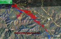
Some of you have asked for a movie version of the Google Earth flyover overview of the San Jose Water Company proposed logging zone....so here it is. [Note, this movie version does not show the photos of redwood trees, beavers, creek scenes and other images contained in the complete Google Earth model, which you view in Google Earth]
This movie portrays the virtual flight up the Los Gatos Creek Canyon, showing the proposed logging zone and its proximity to schools, a children's playground and day care center as well as densely-populated residential communities; also shows where SJWC proposes to stage helicopter landing zones to air-lift out the redwood logs because this watershed land is so steep.
Quicktime movie, 13 MB
(video only - no audio)
Click here to learn about how to view the details of the logging proposal using Google Earth.
To see how we used this information to win the first big battle with SJWC, click here.